
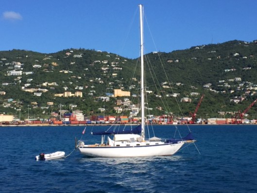
The Far Reach, Anchored, Elephant Bay, St Thomas, USVI–6 Jan 2016
Click clack. Click clack. I woke up about 0400 to a sound I could not immediately identify. “What is that?” “Ah, it’s the sound of a mooring ball banging against the hull of the Far Reach.” There was little wind so the ball was trying to occupy the same space as our hull. I got up and used the boat hook to push it off. The pendant with the pick-up buoy was on one side of the boat and the mooring ball on the other. Back to bed. When I finally got up Tricia had the coffee going and was standing at the foot of the companionway looking out over the bridge deck and across the stern of the Far Reach taking in the lovely tropical panorama.
We had a quick breakfast and took the dinghy into Cruze Bay to get some gas for the dinghy outboard and look for a chart of St Thomas as the one I had on board did not cover the whole island. In fact it only covered half of the main harbor at Charlotte Amalie. “No place sells charts here” I was told. “You have to go to St Thomas to get a chart of St Thomas.” “But how do I get to St Thomas without a . . . Oh never mind.”
We have used paper charts for the whole trip. I like them. I like plotting the Lat/Long on paper. I think it connects me to the surroundings in a way a chart plotter does not. It’s timeless. In a small way, I briefly rub elbows with those that went before. But charts are getting hard to come by, and they are expensive. I am using the grey scale reproductions sold by Bellingham Charts. They are OK. Reasonably priced but not especially durable. But let me tell you, when you don’t have the chart you need it gets interesting fast as the price of the chart falls pretty low on the priority list.
We returned to the boat empty handed and slipped the mooring about 1055. A late start to be sure. The breeze was light. We sailed with the working jib, stays’l , and the main with one reef in it expecting the wind to pipe up as we cleared wind shadow behind the south west point of St John island.
We started on a broad reach but once we cleared Stevens Cay, we came up onto the wind and were close hauled on a course of 180 degrees magnetic. We could not take the short cut past Great St James Island because the chart I had lacked the necessary details. So we sailed a couple more miles south, tacking twice, to get around Dog Island. We were back out in the Atlantic Ocean. The swells were not bad, only about 4 feet. The east wind was a pleasant 15-17 kts. Once we had the offing we needed we fell off the wind and steered about 285 degrees magnetic, paralleling the south coast of St Thomas.
We rigged the whisker pole for the jib and once again ran downwind wing and wing. It was delightful. Tricia plotted our position on the chart at the nav station. I sat in the cockpit identifying landmarks and terrain features. Our trusty windvane unfailingly steered the Far Reach as she whisked along over swells to the west.
We finally opened the East Gregorie Channel at Charlotte Amalie and spotted the cruise liners over on the east side of Hassle Island. We ran down Gregorie Channel and gybed at the north end and then reached back along the West Gregorie Channel where many cruising boats are anchored in the lee (west side) of Water Island. We sailed back and fourth a couple times looking for a spot to anchor amongst the numerous mooring balls. This is a long stretch of water well suited to anchoring. We would get more seclusion if we pushed further south but would be further from the facilities we wanted–stores for reprovisioning, mail, laundry, etc. A short dinghy ride or a long wet one. This time, it was an easy decision.
I picked a spot back near the head of the channel across from Crown Bay Marina. While sailing along, Tricia rigged the inflatable dinghy along the starboard quarter of the Far Reach in case we decided to use it as a yawl boat when it was time to anchor. As we were beating back an undetected squall rolled in over the top of Water Island bringing light rain and a gusty 25-30 knots of breeze.
I told Tricia to raise the stays’l which she did and then immediately drop the jib after the stays’l was up. If we dropped the jib first we would have only had the mainsail up for a time, however brief, and it would have been hard to tack without a headsail so we needed that stays’l up before we could drop the jib and reduce our sail area even though the windy was gusting over 20 kts. Tricia handled it like she was in the NFL and sure enough as soon as she handed the jib we needed to tack. But, the stays’l rapidly and reliably brought the bow through the wind and onto the new tack. We ran back along the mooring field in the refreshing rain. We picked out a spot and made a trial pass shooting up into the wind to check our carry. Then, on the next pass we repeated our maneuver but this time we dropped the stays’l and anchored in 25′ of water. I left the main scandalized and used it to back the boat down and set the anchor.
Tricia dove the anchor to see how it was set. It was upside down on a sandy bottom –it was her first time dropping the anchor and I think she let out too much chain too fast. Only the weight of the chain was holding us in place. She dove back down and flipped it over and watched it set. We were anchored in St Thomas, USVI.
Right behind us was one of two cruise ships that we crossed paths with on Christmas Eve off the north bank of the BVI. This particular ship was not kind to us. She failed to respond on VHF as she closed with us. Initially we could not tell her direction as she was so lit up with white lights we could not see her running lights. It’s nerve racking when closing with a large ship at night on the open ocean especially when the conditions are rough as they were that night. Small boat sailors want to know the course and speed of these potential threats so they can ensure they stay out of the way. We had flashed our spot light and used our strobe but there was no response. The ship was closing fast. Finally, she came up on the radio when we flashed the bridge. But, it took another 5-10 minutes for someone that spoke English to come on to the radio. By then, it was a non issue. She had steamed past. Earlier that evening, the cruise liner Regal Princess had come up on the radio immediately — wishing us a Merry Christmas as well — as did many of the ships we encountered during our passage.
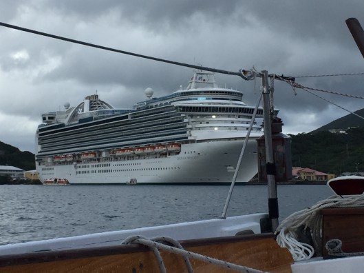
The Regal Princess had wished us a Merry Christmas on Christmas Eve as we prepared to make landfall two weeks early at Jost van Dyke.
While Tricia cleaned up, I took the dingy in and signed us up for a mail drop box. I also found out that AT&T covers the USVI so I had cell phone coverage without roaming. Hooray!!
I talked to some local cruisers and got some good insights into the area for the supplies we needed.
Later, Tricia and I went in for a burger and Guinness to celebrate our fine day of sailing. Tomorrow we get Tricia ready to return home to NC.
