
2 June 2016–The Far Reach, Anchored, Cape Lookout, NC
The Far Reach, safely made landfall at Cape Lookout NC about 1830 yesterday, 1 June. We are anchored at almost the exact spot from which my sister Tricia and I took our departure for the British Virgin Islands on 8 December.
Back at Cape Lookout, where our voyage began six months earlier
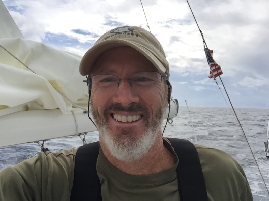
We–the Far Reach and I–for I singlehanded this voyage, sailed 1,334 nautical miles from St Maarten to Cape Lookout in 12 days. It was a wonderful offshore blue water adventure. We successfully dodged Tropical Storm Bonnie and in fact sailed right under the mostly disintegrated “Low” about 1400 lyesterday (though I now understand she may be regenerating as she moves NE up the coast).
It was mostly down wind sailing (what fun!). Just gorgeous at times with the decks completely dry, even in 25 knots of wind. The foredeck hatch open and the cool tropical breeze blowing through the boat with the self steering windvane reliably steering us regardless the conditions. I read, napped, cooked, read some more, navigated, napped some more, practiced my celestial navigation, wrote in the log book, and spent hours gazing out to sea just marveling at this beautiful planet and so grateful to be able to do what I have dreamed of doing since I was 12 years old.

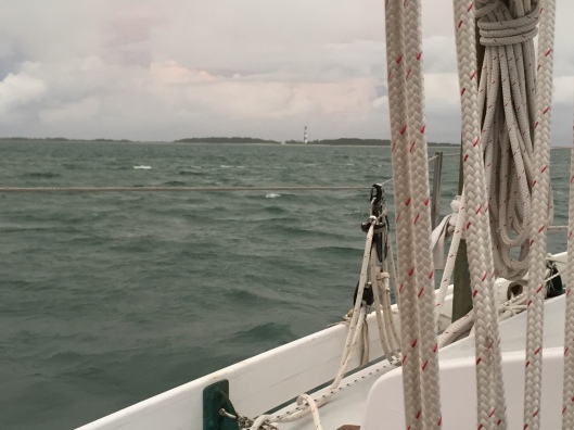
We had some glorious sailing.
We had some wonderful 140+ mile runs offset by some slow sailing as we ran into light winds. We also experienced numerous night time squalls with rain, lightening, and high wind. We made 90 miles in 13 hours at one point but then shortened sail during the night which slowed us down. I shortened sail almost every night to reduce the likelihood of “high adventure” with so many squalls about. Big sails and efficient rig configurations that can be reasonably handled while singlehanding in daylight can be extraordinarily difficult to deal with when running downwind in the dark in big seas.
There were some anxious moments too when it finally became apparent that Tropical Depression#2, declared a Tropical Storm and given the name Bonnie, had the same destination that we did. Chris Parker, a first class weather router, recommended we remain well behind Bonnie, which we did. I only have an HF receiver so I could not talk to him but I sent a twice daily SPOT report so he had our Lat/Long and would would transmit, in the blind, weather info specific to our location twice a day.

We were not always alone out there.
For the last four days or so it was just plan squally weather, as we closed on the remnants of TS Bonnie with a number of scary electrical storms–you know the kind, where the flash and the bang are about the same time! Fortunately, the wind speed in the squalls was moderate (30-35 knots). We had some torrential rain and some very light wind too, where we just ghosted along. But that was magnificent as well. I was visited by several Tropic Birds and of course saw many flying fish. I saw my first Portuguese Man-of-War about 250 miles off the coast.
In a few days, I’ll post some more pictures when I get the Far Reach safely in her berth at Cherry Point. I shot of a fair amount of GoPro HD video and took a bunch of HD stills as well, which I need to sort through. I am presently anchored at the “Bight” at Cape Lookout waiting for some settled wether and a cooperative tide to shoot the Beaufort Inlet and clear customs. From there about 22 NM to the marina at Cherry Point.
The voyage home was fantastic (epic in my world) as was the entire six month trip to the eastern Caribbean. I can’t wait to do it again!
It was an epic adventure.

Kudos John ! What and epic adventure. All you’re hard work paid off. Looking forward to more pictures
LikeLike
WELCOME HOME, Sailor !!!! BZ !!!! Can’t wait to see the rest of your pictures/video !!!
LikeLike
WELCOME HOME, Sailor !!! Can’t wait to see the rest of your pictures/videos !!! BZ!!!
LikeLike
It was terrific to follow this adventure. Great to see your success! Thanks for attention to detail, many observations, the sort that make it such a shared journey via the net. Thanks!
LikeLike
I echo what JimB and Bill said above – fun to follow your travels! Last week we were (again) at the homeschool convention in NC manning the Sonlight booth and I was thinking about your adventure. Kudos on a trip well done!
LikeLike
Michael,
I plan to be at the conference this coming spring in preparation for their last year of high school. Hooray!
I am glad you enjoyed the blog.
Best regards
John
LikeLike
What a great trip John. Sounds like wonderful sailing and a really satisfying and peaceful time alone. Nice to read a bit how you have balanced some modern technology with the goal of simplicity. Looking forward to the videos. Congratulations!
LikeLike